


Hanover Voting District, Cape Girardeau County, Missouri
About
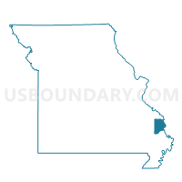
Outline

Summary
| Unique Area Identifier | 607373 |
| Name | Hanover Voting District |
| County | Cape Girardeau County |
| State | Missouri |
| Area (square miles) | 20.62 |
| Land Area (square miles) | 20.57 |
| Water Area (square miles) | 0.06 |
| % of Land Area | 99.73 |
| % of Water Area | 0.27 |
| Latitude of the Internal Point | 37.39481070 |
| Longtitude of the Internal Point | -89.57197340 |
Maps


Graphs
Select a template below for downloading or customizing gragh for Hanover Voting District, Cape Girardeau County, Missouri


Neighbors
Neighoring Voting District (by Name) Neighboring Voting District on the Map
- Byrd No. 1 Voting District, Cape Girardeau County, MO
- Byrd No. 4 Voting District, Cape Girardeau County, MO
- Byrd No. 6 Voting District, Cape Girardeau County, MO
- Cape Girardeau Precinct 1, Cape Girardeau County, MO
- Cape Girardeau Precinct 16, Cape Girardeau County, MO
- Cape Girardeau Precinct 17, Cape Girardeau County, MO
- Cape Girardeau Precinct 2, Cape Girardeau County, MO
- Fruitland Voting District, Cape Girardeau County, MO
- Neelys Landing/Oriole Voting District, Cape Girardeau County, MO
- Nell Holcomb Voting District, Cape Girardeau County, MO
Top 10 Neighboring County Subdivision (by Population) Neighboring County Subdivision on the Map
- Cape Girardeau township, Cape Girardeau County, MO (40,563)
- Byrd township, Cape Girardeau County, MO (18,646)
- Randol township, Cape Girardeau County, MO (4,431)
Top 10 Neighboring Place (by Population) Neighboring Place on the Map
Top 10 Neighboring Elementary School District (by Population) Neighboring Elementary School District on the Map
Top 10 Neighboring Unified School District (by Population) Neighboring Unified School District on the Map
Top 10 Neighboring State Legislative District Lower Chamber (by Population) Neighboring State Legislative District Lower Chamber on the Map
Top 10 Neighboring State Legislative District Upper Chamber (by Population) Neighboring State Legislative District Upper Chamber on the Map
Top 10 Neighboring 111th Congressional District (by Population) Neighboring 111th Congressional District on the Map
Top 10 Neighboring Census Tract (by Population) Neighboring Census Tract on the Map
- Census Tract 8805, Cape Girardeau County, MO (9,040)
- Census Tract 8812, Cape Girardeau County, MO (6,361)
- Census Tract 8806, Cape Girardeau County, MO (6,347)
- Census Tract 8807, Cape Girardeau County, MO (4,362)